
GeoRank
GeoRank compares every place on earth by sunshine, cost, tax, and visa rules, then lets you ask AI about your shortlist.
VisitPublished on:
July 13, 2026
Pricing:
About GeoRank
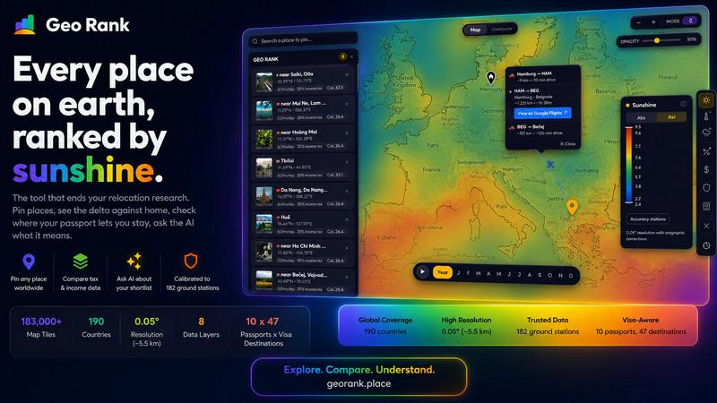
GeoRank is a sophisticated, interactive mapping platform designed to transform the complex process of international relocation research into a single, coherent decision-making experience. Rather than forcing users to juggle a dozen disparate tabs across weather sites, cost-of-living databases, embassy pages, and expatriate forums, GeoRank layers eight critical data sets over a precise global grid of approximately five-kilometer resolution. The platform integrates calibrated sunshine and temperature data from 182 ground stations sourced through SARAH-3, ERA5, and CHELSA, alongside tax rates from OECD, PwC, and KPMG, per-passport visa and residency routes across 47 destinations for 10 passports, cost-of-living metrics from 478 cities, geopolitical risk assessments, and a unique community-sourced Nomad Pulse sentiment indicator. GeoRank is built for the actual decision of where to live next, not merely for browsing data. Users can pin candidate locations, switch to Compare mode to see every metric as a delta against their current home, and engage an AI assistant that reasons exclusively over their own shortlist with cited, grounded answers. It is a free, no-signup tool that replaces exhaustive research with clarity and confidence.
Features of GeoRank
Interactive Global Map with Nine Data Layers
GeoRank presents a fully interactive global map that allows users to pan across any region and zoom down to approximately five-kilometer cells. Nine live data layers are available for toggling, including sunshine, temperature, rainfall, outdoor hours, taxes, visas and residency, cost of living, geopolitical risk, and Nomad Pulse sentiment. Each layer is a calibrated data source with transparent methodology, enabling users to stack multiple layers simultaneously and gain a multidimensional understanding of any location.
Compare Mode with Delta Analysis
The Compare mode transforms absolute data into relative, actionable insights. Users set their current home location as a baseline, and every pinned place in their shortlist is measured against it. Instead of seeing only raw numbers, users observe deltas how many more sunshine hours, how much cheaper the cost of living, how much safer the geopolitical environment, or how differently the tax regime operates compared to their current reality. This feature provides immediate, personalized context for every decision.
AI Assistant Grounded in Your Shortlist
GeoRank includes a sophisticated AI assistant that operates exclusively on the user's pinned locations, not a generic knowledge base. The assistant can answer complex comparative questions such as which of five pinned places has the best winter or how to score a shortlist by sunshine, cost, and low tax combined. Every answer is cited with grounded data sources, ensuring transparency and reliability. This feature bridges the gap between raw data tables and nuanced personal decision-making.
Nomad Pulse Community Sentiment Layer
The Nomad Pulse layer tracks weekly sentiment from the global digital nomad community by processing social posts into rising, stable, or falling signals per country and city. This unique feature captures where enthusiasm is building before it becomes mainstream, offering users a dynamic, community-driven perspective that complements official data sources. It provides a real-time pulse on the desirability and experience of living in various locations.
Use Cases of GeoRank
Relocation Research for Digital Nomads
Digital nomads seeking their next extended stay destination can use GeoRank to evaluate multiple locations against their personal criteria. By pinning candidate cities, setting their home base, and comparing deltas for sunshine, cost, tax, and visa freedom, they can quickly identify the optimal balance. The AI assistant can then answer nuanced questions about seasonal weather, tax implications for foreign-sourced income, and community sentiment, all grounded in the user's specific shortlist.
Family Relocation Decision Making
Families considering an international move can leverage GeoRank to assess trade-offs between locations based on safety, cost of living, climate, and residency pathways. The platform allows parents to compare school-friendly climates, evaluate geopolitical risk levels, and understand visa options for all family members. The AI assistant can reason across multiple criteria simultaneously, helping families weigh complex factors like winter temperatures against annual cost differences.
Retirement Planning Abroad
Retirees exploring overseas options can use GeoRank to identify locations that offer favorable tax regimes, lower cost of living, and desirable climates. By pinning potential retirement destinations and comparing them against their home country, they can see clear deltas in healthcare costs, sunshine hours, and geopolitical stability. The visa layer provides critical information on residency routes and passport requirements, while the AI assistant can answer specific questions about long-term stay implications.
Investment Property Research
Real estate investors and property buyers can utilize GeoRank to evaluate locations based on a combination of climate desirability, economic stability, tax treatment, and community growth signals. The Nomad Pulse layer offers insight into emerging hotspots, while tax data from authoritative sources helps assess the financial viability of different markets. The compare mode allows investors to benchmark potential properties against their current portfolio locations.
Frequently Asked Questions
How does GeoRank calibrate its sunshine and temperature data?
GeoRank merges SARAH-3 satellite observations with ERA5 reanalysis data, then bias-corrects the results against 182 ground stations worldwide, including stations in Reykjavik, Phoenix, and Sydney. Orographic terrain corrections are applied to account for high-altitude and coastal microclimates. The result is accuracy within plus or minus eight percent for most locations, with slightly wider margins for high-altitude and coastal areas.
Is there a cost to use GeoRank, and do I need to create an account?
GeoRank is completely free to use and requires no signup or account creation. Users can access all features, including the interactive map, data layers, compare mode, and AI assistant, without providing any personal information. Pinned locations are saved across sessions automatically through browser storage.
How does the AI assistant ensure its answers are accurate and trustworthy?
The AI assistant operates exclusively on the user's pinned locations and the specific data sets available within GeoRank. It does not draw from a generic knowledge base or the broader internet. Every answer includes cited sources, such as GeoRank sunshine data, OECD Tax Database, or PwC Worldwide Tax Summaries, allowing users to verify the information and understand the reasoning behind each recommendation.
What is the Nomad Pulse layer and how is it generated?
The Nomad Pulse layer tracks weekly sentiment from the digital nomad community by analyzing social media posts and community discussions. The data is processed into three signals per country and city: rising, stable, or falling. This provides a real-time indicator of where enthusiasm and positive experiences are building within the nomadic community, offering a dynamic complement to static official data sources.
Similar to GeoRank

screenRIG
Signage and kiosk infrastructure for AI agents. Your agent publishes images, video, streams, web pages and apps to screens via one plugin.screenRIG is

GetYouTubeTranscript
Free YouTube transcripts on the web, a Chrome extension, and an API + MCP server so AI assistants can read YouTube.
Tally Counter
Online tally counter for tracking attendance, workouts, inventory, visitors, sports scores, habits, and everyday counting tasks.



Free Gemini Omni
Create, remix, and edit cinematic AI videos online with Free Gemini Omni using text, image, audio, and video prompts.