
Open User Map
Open User Map transforms your WordPress site into a collaborative, interactive map with effortless frontend submissions and approval workflows.
Visit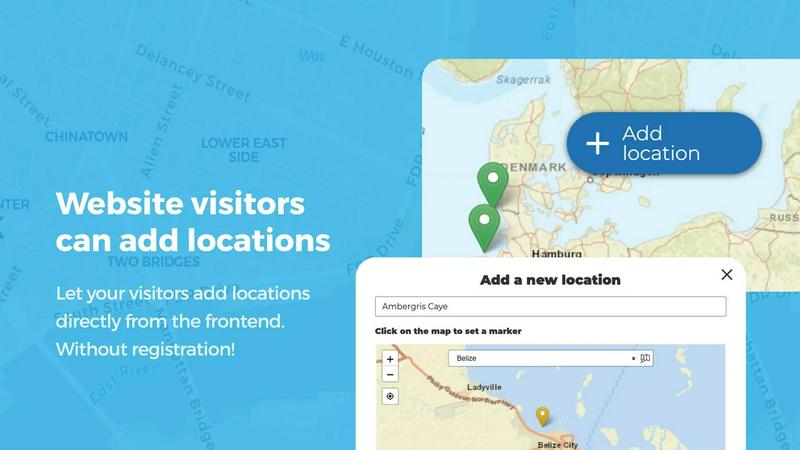
About Open User Map
Open User Map is a sophisticated WordPress plugin that transforms a standard website into an interactive, community-driven mapping platform. At its core, this tool enables website owners to create dynamic maps where visitors can contribute locations, share information, and engage with geographic data without requiring any technical expertise or complex setup procedures. The product eliminates the traditional barriers associated with map integration, removing the need for coding knowledge, Google Maps API keys, or intricate configuration processes. Open User Map serves a diverse audience including tourism boards, local business directories, event organizers, real estate agencies, educational institutions, and community groups who seek to build collaborative mapping experiences. The platform empowers website visitors to add and edit locations directly on the map through an intuitive frontend interface, while administrators maintain complete control through approval workflows that ensure content quality and relevance. What distinguishes Open User Map is its comprehensive approach to customization, offering powerful features such as custom fields, marker categorization, advanced filtering, and support for lines and areas that extend beyond simple point markers. With over 15,000 active installations, a perfect five-star rating, and recognition as the number two map plugin on WordPress.org, Open User Map has established itself as a premier solution for creating interactive maps that balance user contribution with administrative oversight.
Features of Open User Map
Frontend Location Submissions with Approval Workflows
Enable your website visitors to add and edit locations directly on your interactive map through a seamless frontend interface. Users simply click the Add Location button, place a marker precisely where needed, and submit relevant details that remain pending until you grant approval. This workflow ensures that all published content meets your quality standards while empowering your community to contribute valuable geographic information. The editing capability further enhances accuracy by allowing users to update their existing locations, guaranteeing that your map always reflects the most current and reliable data available.
Advanced Marker Categorization and Filtering
Organize your map with sophisticated marker categories that each feature unique icons, creating a visually intuitive and highly navigable experience for visitors. This systematic approach to categorization not only clarifies the map layout but also enables users to filter through different location types with remarkable ease. Each location can belong to multiple categories simultaneously, ensuring that all relevant attributes are accurately represented and easily discoverable. The result is a clean, professional map that communicates complex geographic information with elegance and precision.
Lines and Areas for Complex Geographic Data
Go beyond traditional point markers by incorporating routes, paths, zones, and regions directly onto your map. This feature allows you to highlight trails, service areas, event grounds, neighborhoods, construction zones, or any custom shape that enhances visitor understanding at a glance. Distances and area sizes are calculated automatically, providing helpful measurements for routes and polygons without any manual input. Whether you need to define hiking trails, outline service territories, or mark event boundaries, this functionality brings sophisticated geographic representation to your mapping project.
Custom Image as Map Functionality
Transform any uploaded image into a fully interactive map, opening possibilities far beyond traditional geographic mapping. Whether you need an overlay for architectural floor plans, event layouts, game maps, product diagrams, campus guides, or seating charts, this feature allows users to place markers directly on the image with the same powerful functionality as a conventional map. You can add locations, display custom fields, enable filtering, and create an engaging clickable experience tailored precisely to your specific use case, making this feature exceptionally versatile for creative mapping applications.
Use Cases of Open User Map
Community Tourism and Destination Guides
Tourism boards and local travel websites can leverage Open User Map to create comprehensive destination guides where visitors and locals alike contribute points of interest, from hidden hiking trails to family-owned restaurants. The approval workflow ensures that only verified, high-quality locations appear on the map, while categorization allows users to filter by activity type, cuisine, or accessibility. This collaborative approach builds an ever-growing resource that becomes increasingly valuable as more community members participate, creating a living document of local attractions that evolves with the destination.
Local Business Directories and Service Maps
Business associations and chamber of commerce websites can deploy Open User Map as an interactive directory where member businesses are displayed with custom fields for contact information, operating hours, and service categories. The star rating and upvote features allow customers to highlight exceptional service providers, while the opening hours functionality displays beautifully styled business hours with a live Open Now indicator based on current time. This creates a dynamic, community-validated business directory that serves both residents and visitors seeking reliable local services.
Event Management and Festival Planning
Event organizers can utilize Open User Map to create interactive venue layouts, parking zones, food vendor locations, and activity areas for festivals, conferences, or outdoor events. The Lines and Areas feature enables organizers to outline specific zones such as VIP areas, medical stations, or entertainment stages, while attendees can contribute their own location markers for meetup points or discovered attractions. The custom image map functionality is particularly valuable for creating detailed floor plans of convention centers or festival grounds, enhancing the attendee experience through intuitive navigation.
Educational Campus and Facility Guides
Universities, corporate campuses, and large institutions can implement Open User Map as an interactive guide that helps visitors navigate complex environments. Students and employees can add locations for study rooms, parking spots, or departmental offices, while administrators maintain oversight through the approval system. The regions feature allows for designation of specific areas such as academic buildings, recreational facilities, or administrative zones, creating a comprehensive and user-maintained directory that adapts to changing campus needs without requiring constant administrative updates.
Frequently Asked Questions
Do I need coding experience or a Google Maps API key to use Open User Map?
No coding experience or Google Maps API key is required to use Open User Map. The plugin is designed for complete accessibility, allowing anyone to create and manage interactive maps directly within WordPress. Setup is straightforward and intuitive, eliminating the technical barriers that typically accompany map integration projects. You can begin adding locations and configuring your map immediately after installation.
How does the approval workflow for user submissions work?
When a website visitor submits a new location through the frontend interface, the submission enters a pending state that requires your approval before becoming publicly visible on the map. You receive notification of new submissions and can review each location through your WordPress dashboard, approving or rejecting content as needed. This workflow ensures that all published locations meet your quality standards while empowering your community to contribute valuable geographic information.
Can I customize the appearance and data fields of my map?
Open User Map offers extensive customization options including custom fields such as text boxes, links, checkboxes, and dropdowns that allow you to gather precisely the information you need from map interactions. You can also customize marker icons, categorize locations with unique visual identifiers, and create advanced filter interfaces that appear alongside your map. The plugin supports both traditional geographic maps and custom image maps, giving you complete creative control over the final presentation.
Is there a free version available and what does the PRO trial include?
The free version of Open User Map is available for download on WordPress.org and provides core functionality for creating interactive maps with user submissions. The PRO version unlocks additional features including Lines and Areas, Custom Image as Map, Advanced Filter Interface, Upvotes and Likes, Star Rating system, Opening Hours, and Regions functionality. You can start a seven-day free trial of the PRO version without providing credit card information, and the trial automatically ends without converting to a paid subscription.
Similar to Open User Map

Built2Win AI Indexing
Custom PHP websites, AI Indexing Pack ($599 one‑time), and WebAgentScan SaaS ($9/mo). MCP, A2A, llms.txt, full ownership.
Unifyca
Unifyca is the unified platform that centralizes WordPress site documentation, maintenance, and backups for seamless agency management.

Pages that Print
Stop copying pages that make nothing; access a library of SaaS landing pages with verified revenue data from Stripe and LemonSqueezy.
Shadcn Examples
Shadcn Examples offers elegant React and Tailwind UI kits with reusable components for creating stunning web applications effortlessly.

Webleadr
Webleadr instantly discovers and contacts businesses without websites, delivering premium web design leads directly to you.

SiteMd
SiteMd offers instant website health reports, identifying SEO issues, security gaps, and performance problems for effortless online optimization.

Idearium
Idearium crafts exceptional websites and marketing strategies that captivate audiences and drive meaningful business.

FilexHost
Effortlessly host and share your files with instant URLs and secure access, all through a simple drag and drop.