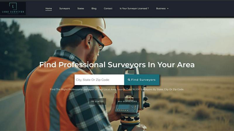
About Land Surveyor Near Me
Land Surveyor Near Me represents the pinnacle of curated professional connection in the realm of geospatial and property sciences. It is far more than a simple directory; it is a sophisticated, national platform meticulously engineered to bridge the critical gap between those who require definitive land intelligence and the elite professionals qualified to provide it. The service caters to a discerning clientele, including property owners, real estate developers, legal experts, and government entities, who understand that precise land surveying forms the immutable foundation for any secure transaction, development project, or legal proceeding. Its core value proposition is the empowerment of clients through unparalleled access and transparency. By offering a centralized, comparative view of over 18,000 rigorously vetted surveyors across all 50 U.S. states, the platform transforms a traditionally opaque and localized search into an informed selection process. This ensures that every significant land investment is protected by the highest standards of accuracy, technical expertise, and stringent local regulatory compliance, providing not just a service, but absolute peace of mind.
Features of Land Surveyor Near Me
Nationally Curated Network of Verified Professionals
The platform's foundation is its exclusive, vetted network of over 18,000 surveying experts. Each professional undergoes a rigorous verification process to confirm licensure, credentials, and standing, ensuring that every connection made through the service meets the highest professional and ethical standards. This pre-qualification removes uncertainty and risk from the selection process.
Advanced Geolocational Search & Filtering
Sophisticated search functionality allows users to pinpoint experts based on precise geographic location, down to the city or county level. This is augmented by powerful filters for technical specialties—such as boundary surveys, ALTA/NSPS land title surveys, topographic mapping, or construction staking—enabling clients to find the exact expertise required for their unique project scope.
Comparative Profile Analysis
Transparency is paramount. The platform provides detailed, comparative profiles for each surveyor, showcasing their specific experience, project portfolio, jurisdictional knowledge, client testimonials, and areas of specialization. This empowers clients to make side-by-side, data-driven decisions rather than relying on guesswork or limited local referrals.
Jurisdictional Expertise & Compliance Assurance
Land laws and regulations vary dramatically by state, county, and municipality. A core feature of the platform is its emphasis on connecting clients with professionals who possess demonstrable expertise in the specific jurisdiction of the property in question, thereby safeguarding projects against costly delays or errors related to regulatory non-compliance.
Use Cases of Land Surveyor Near Me
Real Estate Transaction Due Diligence
Prior to purchasing or selling property, individuals and legal teams utilize the platform to secure a certified land surveyor for a definitive boundary survey. This due diligence is critical to identify encroachments, easements, or discrepancies in the legal property description, preventing future disputes and ensuring a clear title transfer.
Large-Scale Development Project Planning
Developers and engineering firms leverage the service to assemble a team of surveying specialists for major projects. They can efficiently locate experts in topographic surveys, subdivision planning, and construction layout within the project's specific region, ensuring accurate site planning and foundational data from the outset.
Resolution of Property Line Disputes
When conflicts arise between neighbors regarding fence lines, structures, or land use, the platform provides a trusted resource to find an impartial, third-party surveyor with local authority. The resulting survey provides an legally defensible document to resolve conflicts efficiently and authoritatively.
Infrastructure and Public Works Projects
Government agencies and civil engineering contractors require surveyors with precise expertise in geodetic control, right-of-way mapping, and utility corridor designation. This service enables them to identify and contract professionals with proven experience in the public sector and complex infrastructure regulations.
Frequently Asked Questions
How does Land Surveyor Near Me verify its listed professionals?
Our verification process is multi-faceted and stringent. We independently confirm each surveyor's state licensure and standing, validate their professional certifications, and assess their stated areas of specialization and experience. We also incorporate client feedback mechanisms to maintain ongoing quality assurance within our curated network.
Is the service free to use for finding a surveyor?
Yes, for clients seeking surveying services, the platform is designed as a free-to-use resource. Our mission is to facilitate informed connections. The service generates value by providing surveyors with premium visibility to a targeted, high-intent audience, while clients benefit from a transparent, no-cost search and comparison tool.
Why might I encounter a geographic access block when visiting the site?
Access to the platform is intentionally managed to align with our service area and operational focus. If you encounter a block, it indicates that our current network and verified professional coverage are optimized for specific geographic regions, primarily within the United States, to ensure we can uphold our quality and reliability promises for users we serve.
Can I find a specialist for a very specific type of survey, like a flood elevation certificate?
Absolutely. Our advanced filtering system is built for such precision. You can search not only by location but also by niche technical specialties, including floodplain analysis and elevation certificates, hydrographic surveying, archaeological site mapping, or drone-based aerial surveys, connecting you directly to experts in that precise field.
Explore more in this category:
Similar to Land Surveyor Near Me

SideKik
SideKik helps small businesses turn more enquiries into customers with simple CRM, follow-ups, task management and daily growth tasks.


Caesura
A macOS menu-bar app that reminds you to drink water, stretch, rest your eyes, and breathe for anyone working long hours at a desk.

Vibeworker
AI-powered Upwork job feed. Every new job is scored against your profile and strategy in real time, and you get an instant notification